Archaeology has been making great strides in recent years thanks to airborne sensors and non-invasive methods on the ground. Drones and aircraft with LiDAR (lasers that “drill” through” the canopy of forests) produce ultra-detailed 3D maps of the terrain, revealing hidden city beads: straight roads, pyramids, water channels, walls and agricultural terraces. In the Mayan regions, extensive LiDAR scans have rewritten the scale of urbanization—with networks of paths (sacbeob) and dense centers that today number millions of inhabitants at their peak, based on aerial measurements updated in recent years. These aerial mappings have also revealed new cities like Valeriana in the forests of Campeche, with clear signs of political centers (pyramids, enclosed plazas, playgrounds).
The same revolution has affected the Amazon: LiDAR has revealed “low-density urbanizations”—sprawling cities with canals and reservoirs—like the Casarabe culture in Bolivia, challenging the idea that the rainforest was empty in antiquity. Combining aerial datasets is rapidly increasing the number of “traces” of pre-Columbian settlements across the basin, creating a whole new map of inhabited landscapes.
In Asia, Angkor and the surrounding cities were “rediscovered” by LiDAR aircraft: beneath the forest, networks of roads, city blocks, and reservoirs were seen connecting the monumental temple to a vast metropolis. This data not only adds to our understanding of Khmer urban planning, but also shows how water infrastructure was the heart of the city.
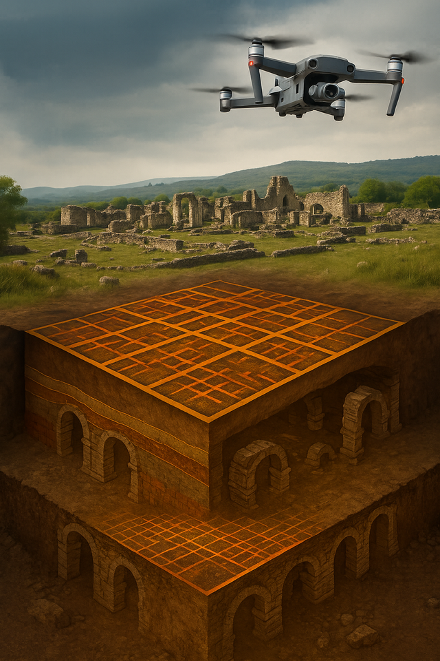
After the sky reveals the structures, ground-penetrating radar (GPR) “photographs” them without touching the ground. In central Italy, researchers mapped the entire Roman city of Falerii Novi with GPR alone, revealing the temple, market, baths, and street network at various depths—an example of how the architecture of an entire city can be read without a shovel. Similar projects have dramatically increased the “sight” underground around Stonehenge, where GPR, magnetometry, and 3D scans were combined into a single GIS.
How does it work in practice?
It usually starts with LiDAR flights (drones/planes) that produce a millimeter-scale “point cloud.” Algorithms and archaeologists’ eyes virtually clear vegetation, extract the terrain pattern, and spot “unnatural” (angular, repetitive) shapes. Then, field teams enter with GPR, magnetometer, or electrical resistivity to confirm wall thickness, building layout, and road traces. All of this is put together into a multi-layered map that allows researchers to decide where a small survey is worth it (if at all), saving time, money, and – most importantly – protecting the site. The examples above show that this approach is becoming the standard, from tropical jungles to European plains.
What don't these methods do?
They don’t “see” everything: GPR depends on soil type and moisture; LiDAR “sees” shape, not date—archaeological dating still requires samples. Also, interpretation can yield “false positives,” so field verifications remain important. But the balance is clear: aerial archaeology and geophysics are replacing large blind excavations with accurate diagnoses and minimal intervention. In many cases, lost cities are being fully mapped without even opening a single excavation profile.
Why does it matter?
These techniques preserve layers for future generations, reduce the cost of projects, speed up research, and help local communities participate in documenting their heritage. For the public, translating data into 3D models makes invisible history accessible—allowing us to “walk” through cities that time has erased from the surface but not from the map.